
Tuckerman Ravine 4/14/2018
After volunteering at Hermit Lake during yesterday's Inferno race, I hiked part way up Hillman's Highway and skied down to Pinkham via the Sherburne Trail. There was a slight break in the cloud cover which allowed for some visibility, but freezing rain started as I hiked up. There was moderate avalanche danger and the snow had turned to ice, so I only bootpacked up as far as the turn. Reports from those who went above that point were that it wasn't worth it to go higher. The hard part was clipping into skis on the edge of Hillman's, but we got it done. The run down was very fast and icy all the way to Pinkham with frozen hard moguls. Bare spots are showing through on parts of the Sherbie, but it was still easy to ski continuously.
View from Hermit Lake The Ravine from Hermit Lake
 Morning view from the Base of Hillman's
 Skiers at the Base of Hillman's
 Afternoon View from Hillman's
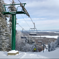
 Hillman's Highway
 Hillman's Highway
 Ready to Drop in
 Hillman's Highway
 Sherburne Trail
 Sherburne Trail
 Sherburne Trail
View from Hermit Lake
The Ravine from Hermit LakeMorning view from the Base of Hillman'sSkiers at the Base of Hillman'sAfternoon View from Hillman'sHillman's HighwayHillman's HighwayReady to Drop inHillman's HighwaySherburne TrailSherburne TrailSherburne Trail - Sam
Comments
Awesome photography!!
Top 7 pics looks Western like
Hey I see ski_it across the valley at the 'cat!
I couldn't believe the number of people in Pinkham on a day like that. Wasn't it dangerous up there?
On the downhill side of Rt 16 a pickup with a cap and kayak had flipped on its side somehow. Looked like an episode from Highway thru Hell. We ran into the same poor pickup on a flatbed followed by a tow truck 3 hours later in Conway on the road to Tucks.
Now these folks have true grit:
The Tuckerman Inferno Pentathlon, based on the original American Inferno ski races of the 1930’s, now consists of an 8.3-mile run, a 6-mile kayak race down the Saco River, an 18-mile bike race north through Pinkham Notch, and a 3-mile run/hike up the Tuckerman Trail to Mount Washington's Tuckerman Ravine. The final leg is a climb up the ravine wall and a ski down a designated giant slalom alpine ski route. Conditions permitting, skiers will finish at the AMC base at Pinkham Notch.
The legs are fine, it's more the feet which hurt from the constant jostling and jolting of the uneven hard snow. There's plenty of snow up in the Ravine, I'd say average for this time of year or maybe a little more, but the Sherburne will probably only be skiable all the way to Pinkham for another week or less.
Great reporting as usual